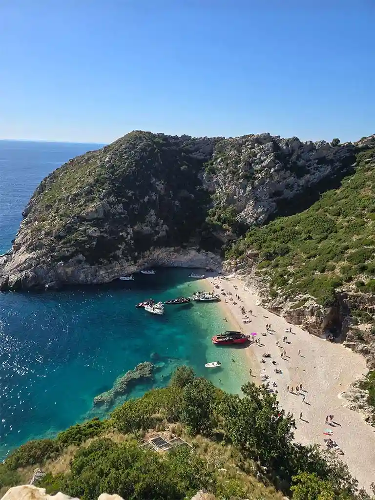
About Grama Bay
Grama Bay sits at the southern end of the Karaburun Peninsula, enclosed on three sides by tall limestone cliffs that drop almost vertically into turquoise water. It is one of the most isolated spots on the entire Albanian coast — no road reaches it, and the only way in is by sea. That isolation is precisely what has kept it intact: the water is exceptionally clear, the shoreline undisturbed, and the surrounding cliffs covered in centuries of accumulated history.
The bay functions as a natural harbour, calm and sheltered even when the open sea outside is choppy. Sailors have been taking advantage of this for over two thousand years, and the evidence of their presence is still visible on the rock — hundreds of inscriptions left by those who stopped here, scratched into the stone at the waterline and above it, covering a span of history from ancient Greece to the Byzantine period.
The Inscriptions
The cliff walls at Grama Bay carry one of the most remarkable collections of ancient maritime inscriptions in the Adriatic and Ionian region. Carved directly into the limestone, they include names, dedications, prayers and messages left by Greek sailors, Roman soldiers, Byzantine travellers and traders who sheltered here during their sea voyages. Some date back to the 4th century BC, making this site a document of continuous human activity spanning nearly two millennia.
The name of the bay itself is thought to come from the Greek word gramma, meaning letter or inscription — a direct reference to the writings on its walls. The inscriptions are concentrated along the lower cliff faces, close to where boats would have anchored, and they range from simple names to longer dedications to gods and patrons. They have been studied by archaeologists and historians as evidence of the bay's role as a regular stopping point on ancient sea routes between the Adriatic and Ionian coasts.
Seeing them up close from the water is one of the more unusual experiences this part of Albania offers — ancient handwriting on a cliff wall, in a place that still looks much the same as it did when those sailors were here.
History & Strategic Importance
Grama Bay's position at the southern tip of Karaburun made it a natural waypoint for sea traffic moving between the Adriatic and Ionian coasts. Ships rounding the peninsula in either direction would pass close to the bay, and its sheltered interior made it a reliable place to anchor in bad weather or rest before continuing a voyage. This is why it attracted sailors consistently across such a long stretch of history — not because it was a settlement, but because it was useful.
During the Roman period the bay was used both by naval traffic and by merchant vessels trading along the Illyrian coast. Later, during the Byzantine and Ottoman periods, it continued to serve as a shelter for local sailors and traders. The accumulated inscriptions from each of these eras turn the cliff face into an unintentional historical record — each name or prayer adding a layer to a story that spans from classical antiquity to the early modern period.
How to Visit
Grama Bay is only reachable by boat. The journey from Vlore takes roughly 1 hour and 20 minutes by speedboat, passing along the full length of the Karaburun coastline with several stops along the way. Because of the distance, visiting Grama Bay requires a full-day tour — a half-day trip does not allow enough time to reach the bay and return comfortably.
Our Grama Bay full-day tour is the only tour we operate that includes the bay. It departs at 10:30 AM and includes eight stops over eight hours — Haxhi Ali Cave, the Secret Blue Cave, Dafina Bay, the Canyon of Smugglers, Englishman Bay and Church's Cave, before arriving at Grama Bay for around 2.5 hours of free time. That extended stop at the bay gives you time to explore the inscriptions along the cliff base, swim in the bay, and simply take in what makes this place different from every other stop on the route.
Nearby Destinations Along the Route
The journey to Grama Bay passes through some of the most scenic stretches of coastline in southern Albania. Each stop on the route has its own character:
A large sea cave with a wide limestone arch. The speedboat enters the cave during the visit. One of the most photographed spots on the Albanian coast.
A smaller cave where sunlight filtering through underwater openings creates an intense blue glow on the water surface inside.
A quiet cove with clear water and a small pebble beach — a calm swimming stop before the longer stretch south to Grama Bay.
A narrow sea canyon only reachable by boat, with high cliff walls on both sides. One of the more dramatic passages on the full-day route.
A secluded bay with an interesting local history and some of the clearest snorkeling water on the Karaburun coast.
A smaller cave stop on the return leg, named after the rock formation above its entrance that resembles a church arch.
Key Facts
Believed to derive from the Greek word gramma (letter/inscription), referencing the hundreds of carved writings on its cliff walls.
The carvings span from the 4th century BC through the Byzantine era — a continuous record of maritime activity covering nearly 2,000 years.
Grama Bay falls within the Karaburun-Sazan Marine National Park, one of Albania's most significant protected coastal environments.
Among the clearest in the Ionian Sea, with visibility regularly reaching 20–25 metres due to the absence of nearby development or runoff.
Approximately 1 hour and 20 minutes by speedboat, making it the furthest destination from Vlore on any of our tour routes.
No road access exists. The bay is only reachable by boat along the Karaburun coastline from Vlore marina.
Frequently Asked Questions
At the southern tip of the Karaburun Peninsula, approximately 1 hour and 20 minutes by speedboat from Vlore. There is no road access — the only way to reach it is by boat.
Hundreds of names, dedications and messages carved into the limestone cliffs by Greek and Roman sailors, soldiers and Byzantine travellers who sheltered here. They span roughly from the 4th century BC to the Byzantine era.
By booking our full-day Grama Bay tour from Vlore. It is the only tour that reaches the bay, with approximately 2.5 hours of free time at the site.
The name is believed to come from the Greek word gramma, meaning letter or inscription — a reference to the hundreds of ancient carvings found on the bay's cliff walls.
Between May and September when the sea is calm enough for the full-day journey and the water visibility is at its best. Tours run daily throughout this period, weather permitting.